Garmin eTrex Touch 35 Western Europe
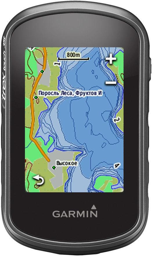
Garmin eTrex Touch 35Tootekirjeldus inglise keeles: Compass, Barometric Altimeter2.6-inch color capacitive touchscreen3-axis tilt-compensated compass and barometric altimeterGPS and GLONASS satellites for faster positioning250,000 preloaded geocaches from Geocaching.com4 GB memory to hold more mapsCompact, rugged and reliable GPS/GLONASS handheld with color touchscreen, featuring a barometric altimeter and 3-axis tilt-compensated electronic compass, wireless connectivity, preloaded geocaches and expanded internal memory to hold more maps.See the WayeTrex Touch 35 features a sunlight-readable, 2.6-inch color touchscreen display offering intuitive access to worldwide basemap with shaded relief. Durable and waterproof, eTrex Touch 35 is built to keep delivering vital mapping and tracking data no matter what the elements throw at you, standing strong against dust, dirt, humidity and water.New Tools for Your TrekeTrex Touch 35 features a built-in 3-axis tilt-compensated electronic compass that shows your heading even when you’re standing still, and you don’t have to hold it level. Also added is a barometric altimeter, which tracks changes in pressure to pinpoint your precise altitude, and you can even use it to plot barometric pressure over time, which can help you keep an eye on changing weather conditions.Go AnywhereWith an array of compatible mounts, eTrex Touch 35 is designed for use on ATVs, bicycles, boats, as a handheld or in your car. Use the auto mount capability and City Navigator® NT maps for turn-by-turn driving directions, or the rugged mount for your motorcycle or ATV. Wherever you think you might take eTrex, it has the mapping and mounts to get you there.Go GlobaleTrex Touch 35 can track both GPS and GLONASS satellites simultaneously. Developed by the Russian Federation, GLONASS satellites “lock on” to a position (on average) approximately 20 percent faster than GPS receivers. Using both GPS and GLONASS means the receiver has the ability to lock on to 24 more satellites than using GPS alone.Add MapsWith its microSD™ card slot and 4 GB of internal memory, eTrex Touch 35 lets you load TOPO maps and hit the trail, plug in BlueChart® g2 preloaded cards for a great day on the water or City Navigator NT map data for turn-by-turn routing on roads. eTrex Touch 35 also supports BirdsEye Satellite Imagery (subscription required) that lets you download satellite images to your device and integrate them with your maps.Stay ConnectedeTrex Touch 35 lets you share your waypoints, tracks, routes and geocaches wirelessly through unit-to-unit sharing to compatible Garmin devices. The smart notification feature means you’ll never miss a text, email or notification from your compatible smartphone*, unless you want to. You can even use your eTrex Touch 35 as a remote control for our VIRB® XE, VIRB X and VIRB Elite action cameras. Keep Your FixWith its high-sensitivity, WAAS-enabled GPS receiver and HotFix® satellite prediction, eTrex Touch 35 locates your position quickly and precisely and maintains its GPS location even in heavy cover and deep canyons.Find FuneTrex Touch 35 is preloaded with 250,000 geocaches from Geocaching.com. By going paperless, you're not only helping the environment, but also improving efficiency. eTrex Touch 35 stores and displays key information, including location, terrain, difficulty, hints and descriptions, which means no more manually entering coordinates and paper printouts. Simply upload the GPX file to your unit and start hunting for geocaches.Plan Your Next TripTake charge of your next adventure with BaseCamp™, software that lets you view and organize maps, waypoints, routes and tracks. This free trip-planning software even allows you to create Garmin Adventures that you can share with friends, family or fellow explorers. BaseCamp displays topographic map data in 2-D or 3-D on your computer screen, including contour lines and elevation profiles. It also can transfer an unlimited amount of satellite images to your device when paired with a BirdsEye Satellite Imagery subscription.
Ametlikud edasimüüjad Hinnavaatluses


Pakkumised
Hinnapakkumised on indikatiivsed. Hinnavaatlus ei vastuta hindade, laoseisude ega tooteinfo õigsuse eest. Lõpliku hinnapakkumise tootele saab toote müüjalt. | |||
Toote tehnilised andmed
| GPS tüüp | Moto GPS |
| Toode lisatud | 2019-05-24 |
Ole esimene, kes toodet kommenteerib