
Tootjad
Hind
Tüübi järgi
Firmad
logo

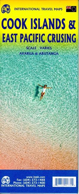
International Travel Maps Cook Islands & East Pacific Cruising: ITM Travel Reference Map

Tootekood: A46277623 GTIN: 9781771291774

his is a combination map, focused on two travel realities. Side 1 is a detailed map of the main islands making up the Cook Island archipelago. To provide more detail, the country is an inset map in the lower left corner, with numbers in blue, up to 15. The main map on Side 1 is a series of inset maps providing excellent detail of individual islands, such as Raratonga, Mangaia, or Aitutaki, or island groupings of more northerly groupings that are little more than atolls, such as Penrhyn or Palmerston. The capital is Avarua, and an inset map is included; also one of Arutanga on Aitutaki. The country is well-positioned for tourism, and has many resorts, particularly on Raratonga. Side 2 is a new map for ITMB, part of our growing Cruising line. This on covers the eastern portion of the South Pacific, from the Marshall Islands, Nauru, and the Solomons on the west to Hawaii and Tahiti on the east, and as far south as New Zealand. Other island nations included on this map are Kiribati, Tuvalu, Fiji, Samoa, and New Caledonia. By the nature of portraying a vast ocean, little detail of each island can be provided. The purpose of this map is to show routes followed by ships visiting the overall region. This is a rapidly-growing travel area for major cruise lines, and promises to be as attractive in the future as cruises in the Caribbean or Mediterranean. This region holds great prospects for the future. Besides, it is a lovely map to look at. Map size: 27*39" when unfolded. Legend Includes: Roads by classification, Rivers and Lakes, National Park, Airports, Points of Interests, Highways, Main Roads, Zoos, Fishing, and much more...

Pakkumised

E-pood
13,09 €

Toote tehnilised andmed

TootekoodA46277623
Min. hind13.09
Max. hind13.09
Toode lisatud2026-04-27

Kommentaarid

Ole esimene, kes toodet kommenteerib